There have been no hurricane landfalls on Florida’s East Coast north of the Keys since Hurricane Katrina made landfall in southern Broward County in August 2005.
There have been tropical threats and serious effects on the Florida peninsula from multiple angles since then: Wilma, Matthew, Irma, Dorian. But no direct landfalls.
That may change in the next 24 hours.
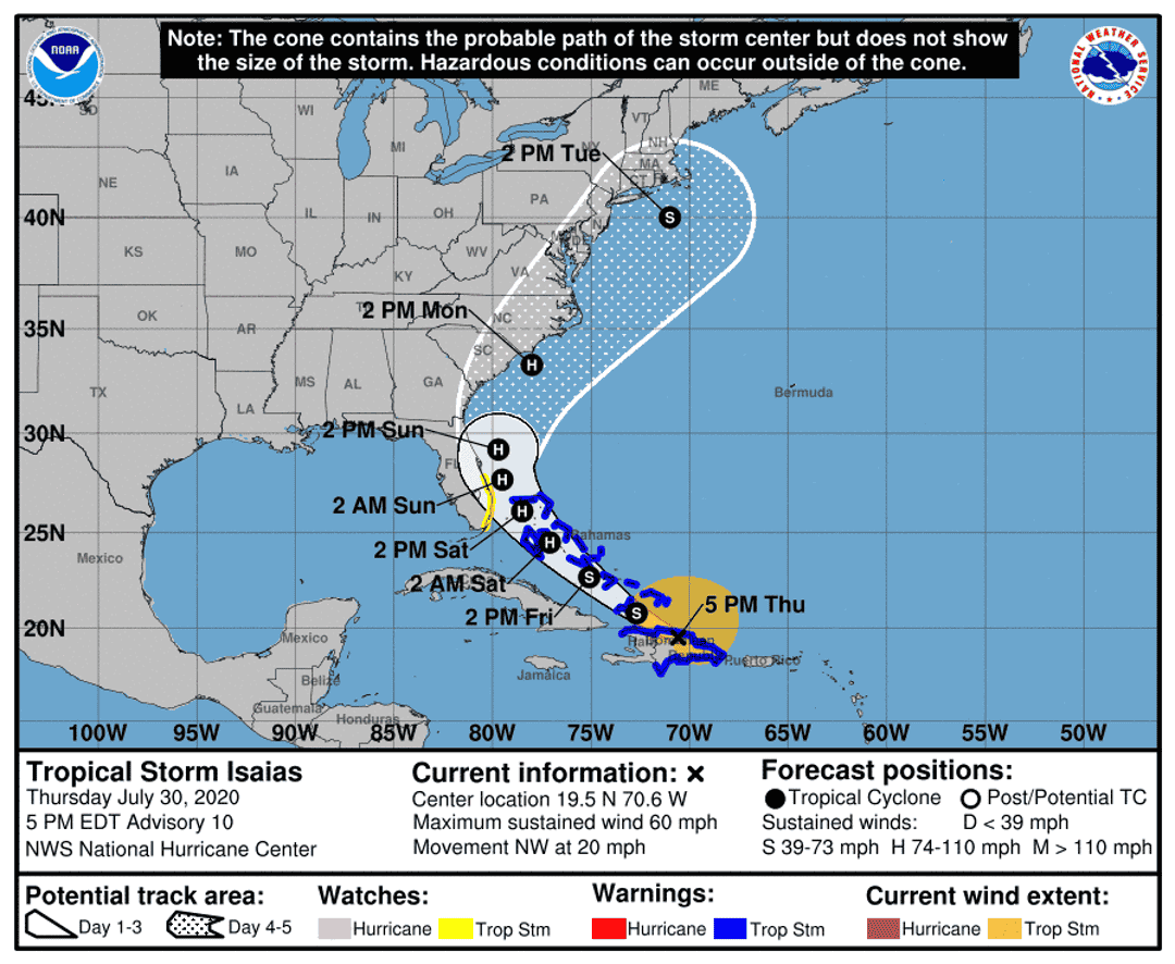
Against the odds, Hurricane Isaias has successfully threaded the needle of Greater Antilles land interaction over the last few days and has arrived on Florida’s doorstep. And while Isaias will contend with a less-than-ideal environment for intensification on final approach, the impacts of a potential Category 1 hurricane landfall should never be taken lightly.
As of 5 p.m., Isaias’ partial eye is located approximately 350 miles southeast of Miami, moving northwest at 15 mph. Maximum sustained winds remain approximately 75 mph, down slightly from a peak of 80 mph early Friday morning. Hurricane warnings are now in effect from Boca Raton north to the Brevard-Volusia County line.
Incredibly, despite tracking lengthwise over mountainous Hispaniola on Thursday, Isaias steadily intensified in transit. As a hurricane researcher, I don’t know how to explain this, other than to say I’ll be reading the master’s thesis surely to be written about it.
Currently, Isaias remains a Category 1 hurricane on the Saffir-Simpson Hurricane Wind Scale, with a compact area of intense convection attempting to surround the circulation center, and a large mass of rainfall extending north and east across the eastern Bahamas.

The asymmetrical structure of Isaias is indicative of brisk wind shear impinging on the hurricane from the southwest. This change in direction or strength of winds with height in the atmosphere is on the order of a brisk 20 knots; in the absence of other unfavorable factors, the 20 to 25 knots of shear expected over Isaias through Sunday is likely to keep intensity relatively unchanged from where it is now prior to landfall, plus or minus 10 mph.
In terms of track, Isaias has tracked a little further west than anticipated across the southern Bahamas. A NOAA flight to sample the ridge to the north of the hurricane that is providing Isaias’ steering currents has found slightly stronger high pressure than expected.
The resulting slight delay in the storm’s turn from a northwest to a north-northwest heading as it reaches the western fringes of the ridge on Saturday may make the difference between landfall in South Florida (followed by an inland track across east central Florida), and a track scraping the Florida East Coast just offshore.
While either remains possible, the new in situ ridge observations and guidance trend tip the scales toward landfall, most likely in Miami-Dade, Broward, or Palm Beach counties Saturday evening or early Sunday morning. One caveat to note is that unexpected strengthening might lead to a track further east or offshore, and unexpected weakening a course further inland.
Because of the continuing southerly shear, most precipitation will be north of the center of circulation. This means that while rainfall in south Florida and east central Florida is likely to be on the order of 2-6 inches, rain totals will drop off sharply over west central Florida and no rainfall or other impacts are expected in the Panhandle.
The strongest winds in the hurricane will be found in the northern half of the eye, with winds likely exceeding 70 mph where the northern eyewall crosses the coastline. Florida’s East Coast and inland east central Florida should prepare for tropical storm force winds Saturday night and Sunday.
A north-northwest track also raises risks of damaging coastal flooding hundreds of miles north of the landfall point, which are associated with strong winds blowing perpendicular to shore. The NHC has issued a Storm Surge Watch for the potential of 2 to 4 feet of surge from Jupiter Inlet to Ponte Vedra Beach. If you are in a known flood zone, please heed any evacuation orders.
In summary, there is a strong possibility yet another long-running hurricane streak is about to fall. Whether or not Isaias technically makes landfall, significant impacts and dangerous weather conditions are expected across much of the eastern half of the Florida peninsula this weekend.
I’ll be back tomorrow to dial in further on expected impacts as Isaias nears Florida. Until then, keep watching the skies.
Dr. Ryan Truchelut is chief meteorologist at WeatherTiger, a Tallahassee start-up providing advanced weather and climate analytics, forensic meteorology and expert witness consulting, and agricultural and hurricane forecasting subscription services. For more information, visit us at weathertiger.com or get in touch at ryan@weathertiger.com.
CORRECTION: An earlier version of this forecast included the incorrect year for Hurricane Katrina.

tinyurlis.gdclck.ruulvis.net
مقالات مشابه
- جورج فلوید وکیل خانواده می گوید پلیس ممکن است شناخته شده و قربانی; تهمت میاد گارد ملی; شهرستانها انتخاب کنید تا قطعات: به روز رسانی زنده
- ردینگ Costco کارمند تحت COVID-19 قرنطینه
- آیا ارتش سپاه منحرف 130 میلیون دلار از EAA مخزن برای کاهش دریاچه اوکیچوبی ترشحات?
- کروناویروس در Treasure Coast, مارس 25: موارد تایید شده در 483; جدید و میر
- Artis—ناپل می شود $1 میلیون تطبیق هدیه برای کمک به تسکین COVID-19 زیان
- راهنمایی کاربردی برای بهبود سئو سایت شما
- California wildfires: August Complex mega fire threatens 'Emerald Triangle' marijuana zone
- نژادی-برابری اعتراضات و راهپیمایی می تواند فشار Indian River مدارس به ملاقات فدرال لغو تبعیض نژادی مشخص منظور
- پیشنهاد ویژه coronavirus جلسه نتواند به عنوان دولت ثبت بالاترین یک روز مورد مجموع در ماه مه
- پیپت آزمایشگاهی چیست؟