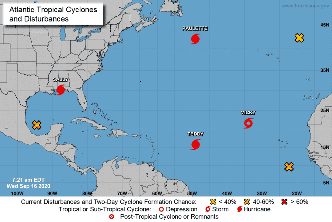
The National Hurricane Center is tracking a total of seven systems over the Atlantic and Gulf of Mexico Tuesday, including three hurricanes, one tropical storm and three other disturbances.
Here's the latest update from the NHC as of Sept. 16.
What's out there and where are they?
Hurricane Sally is 25 miles west-southwest of Pensacola.
Hurricane Paulette is 385 miles south-southeast of Cape Race, Newfoundland.
Hurricane Teddy is 820 miles east of the Lesser Antilles.
Tropical Storm Vicky is about 755 miles west-northwest of the Cabo Verde Islands.
Disturbance 1 is an area of low pressure over the southwestern Gulf of Mexico.
Disturbance 2 is a few hundred miles south-southeast of the Cabo Verde Islands.
Disturbance 3 is a non-tropical area of low pressure is located over the far northeastern Atlantic Ocean a few hundred miles northeast of the Azores.

More: Hurricane Sally, a Category 2 drencher, makes landfall near Gulf Shores, Alabama
More: Hurricane season: Explanation of storm terms
How likely are they to strengthen?
Hurricane Sally: Some slight increase in strength is possible before the center of Sally's eye makes landfall later this morning. Rapid weakening is expected after landfall occurs.
Hurricane Paulette: Although gradual weakening is forecast, Paulette is expected to become a powerful extratropical cyclone later today.
Hurricane Teddy: Some strengthening is forecast during the next few days, and Teddy is likely to become a major hurricane later today and could reach category 4 strength on Thursday.
Tropical Storm Vicky: Gradual weakening is forecast over the next few days, and the system could become a remnant low on Thursday or Friday.
Disturbance 1:
- Formation chance through 48 hours: 20%
- Formation chance through 5 days: 40%
Disturbance 2:
- Formation chance through 48 hours: 50%
- Formation chance through 5 days: 70%
Disturbance 3:
- Formation chance through 48 hours: 20%
- Formation chance through 5 days: 20%
Details on named storms
Hurricane Sally
- Location: 25 miles west-southwest of Pensacola
- Maximum sustained winds: 100 mph
- Present movement: North-northeast at 3 mph
Hurricane Paulette
- Location: 385 miles south-southeast of Cape Race, Newfoundland
- Maximum sustained winds: 100 mph
- Present movement: East-northeast at 29 mph
Hurricane Teddy
- Location: 820 miles east of the Lesser Antilles
- Maximum sustained winds: 100 mph
- Present movement: Northwest at 12 mph
Tropical Storm Vicky
- Location: 755 miles west-northwest of the Cabo Verde Islands
- Maximum sustained winds: 50 mph
- Present movement: West-northwest at 9 mph
Who is likely to be impacted?
Hurricane Sally
Hurricane conditions are spreading onshore within the hurricane warning area in Florida and Alabama. Tropical storm conditions will continue in portions of the warning areas through tonight.
Through this afternoon, Sally will produce additional rainfall totals of 8 to 12 inches with localized higher amounts possible along and just inland of the central Gulf Coast from west of Tallahassee, Florida to Mobile Bay, Alabama. Storm totals of 10 to 20 inches to isolated amounts of 35 inches is expected. Historic and catastrophic flooding is unfolding. In addition, this rainfall will lead to widespread moderate to major river flooding.
Hurricane Paulette
Swells generated by Paulette will continue to affect the Atlantic Canada, Bermuda, the Bahamas, and portions of the east coast of the United States through tonight. These swells are likely to cause life-threatening surf and rip current conditions.
Hurricane Teddy
Large swells generated by Teddy are expected to reach the Lesser Antilles and the northeastern coast of South America today should spread westward to the Greater Antilles, the Bahamas, and Bermuda by Friday. These swells are likely to cause life-threatening surf and rip current conditions.
Tracking the tropics in real time
These graphics, which update automatically, show you activity in the tropics in real time.
Watches/warnings issued
Hurricane Sally
- A Storm Surge Warning is in effect from Fort Morgan Alabama to the Walton/Bay County Line Florida.
- A Hurricane Warning is in effect from the Mississippi/Alabama border to the Okaloosa/Walton County line.
- Florida A Tropical Storm Warning is in effect from east of the Okaloosa/Walton County line Florida to Indian Pass Florida, and from the Mississippi/Alabama border to the Mouth of the Pearl River.
tinyurlis.gdu.nuclck.ruulvis.netshrtco.de
مقالات مشابه
- شرکت صادرات و واردات کالاهای مختلف از جمله کاشی و سرامیک و ارائه دهنده خدمات ترانزیت و بارگیری دریایی و ریلی و ترخیص کالا برای کشورهای مختلف از جمله روسیه و کشورهای حوزه cis و سایر نقاط جهان - بازرگانی علی قانعی
- شرکت صادرات و واردات کالاهای مختلف از جمله کاشی و سرامیک و ارائه دهنده خدمات ترانزیت و بارگیری دریایی و ریلی و ترخیص کالا برای کشورهای مختلف از جمله روسیه و کشورهای حوزه cis و سایر نقاط جهان - بازرگانی علی قانعی
- DeSantis می گوید شلیک COVID-19 دیتا رئیس یک مسئله غیر " هر چند ایمیل می گویند در غیر این صورت
- بررسی جوانب مختلف بازار مالی برای کسب درآمد دلاری
- رنو تالیسمان، شوالیه فرانسوی
- شرکت صادرات و واردات کالاهای مختلف از جمله کاشی و سرامیک و ارائه دهنده خدمات ترانزیت و بارگیری دریایی و ریلی و ترخیص کالا برای کشورهای مختلف از جمله روسیه و کشورهای حوزه cis و سایر نقاط جهان - بازرگانی علی قانعی
- کروناویروس در ساحل گنجینه: آنچه شما نیاز به دانستن در یکشنبه, ژوئن 10
- خود را از کسب و کارهای محلی شما نیاز دارید. خرید یک کارت هدیه در حال حاضر به حمایت از آنها
- طوفان گرمسیری رود به فرم در خلیج مکزیک بعد از امروز; که در آن خواهد شد نامشخص باقی مانده است
- معرفی بهترین شرکت خدمات پرستاری در تهران