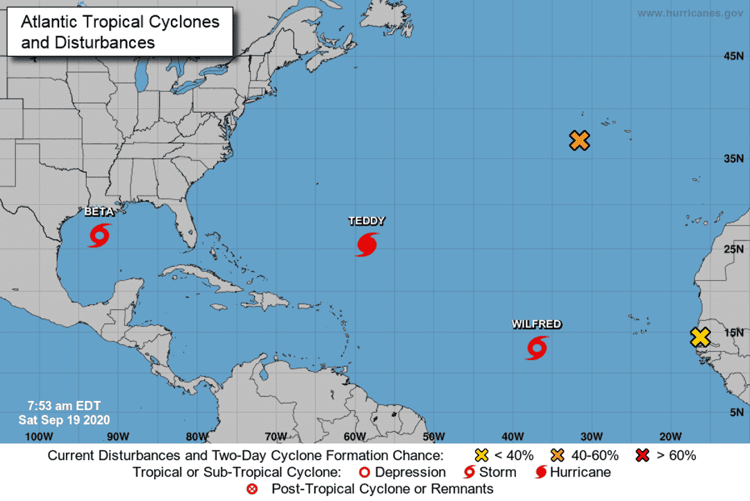
The National Hurricane Center is tracking a total of five systems over the Atlantic and Gulf of Mexico Saturday, including one hurricane, two tropical storms and two other disturbances.
Here's the latest update from the NHC as of Sept. 19.
What's out there and where are they?
Hurricane Teddy is about 605 miles southeast of Bermuda.
Tropical Storm Wilfred is about 885 miles west of the Cabo Verde Islands.
Tropical Storm Beta is 270 miles southwest of the mouth of the Mississippi River.
Disturbance 1, previously Post-Tropical Cyclone Paulette, is a few hundred miles southwest of the Azores.
Disturbance 2 is near the west coast of Africa.
More: Hurricane season: Explanation of storm terms
More: CSU revises hurricane forecast; named storms could be double that of average year
How likely are they to strengthen?
Hurricane Teddy: Maximum sustained winds are near 125 mph with higher gusts. Some fluctuations in intensity are likely today. A more pronounced decrease in Teddy's maximum winds is forecast to begin on Sunday, but the wind field of the hurricane is forecast to increase substantially at the same time.
Tropical Storm Wilfred: Maximum sustained winds are near 40 mph with higher gusts. Small fluctuations in intensity are possible over the weekend. A general weakening trend should begin by late Sunday and Wilfred is forecast to become a remnant low in a few days.
Tropical Storm Beta: Maximum sustained winds are near 60 mph with higher gusts. Slow strengthening is forecast, and Beta is expected to become a hurricane on Sunday.
Disturbance 1:
- Formation chance through 48 hours: 40%
- Formation chance through 5 days: 50%
Disturbance 2:
- Formation chance through 48 hours: near 0%
- Formation chance through 5 days: 10%
Details on named storms
Hurricane Teddy
- Location: 605 miles southeast of Bermuda
- Maximum sustained winds: 125 mph
- Present movement: Northwest at 14 mph
Tropical Storm Wilfred
- Location: 885 miles west of the Cabo Verde Islands
- Maximum sustained winds: 40 mph
- Present movement: West-northwest at 17 mph
Tropical Storm Beta
- Location: 270 miles southwest of the mouth of the Mississippi River
- Maximum sustained winds: 60 mph
- Present movement: North at 8 mph
Who is likely to be impacted?
Hurricane Teddy
Tropical storm conditions are expected to affect Bermuda and beginning Sunday afternoon or evening. These conditions may linger through most of the day Monday.
Large swells generated by Teddy are affecting the Lesser Antilles, the Greater Antilles, the Bahamas, and Bermuda. Swells from Teddy will begin affecting most of the east coast of the United States later today and will reach Atlantic Canada by early Sunday. These swells are likely to cause life-threatening surf and rip current conditions.
Tropical Storm Beta
Hurricane conditions are possible along the Texas coast between Port Aransas and High Island by late Monday.
Tropical storm conditions are possible along the upper Texas and southwestern Louisiana coast as early as tonight.
There is an increasing risk of significant rainfall and flooding along the Texas and Louisiana coasts from Sunday through at least the middle of next week as Beta is forecast to move slowly near the Texas coast.
Tracking the tropics in real time
Watches/warnings issued
Hurricane Teddy
- A Tropical Storm Warning is in effect for Bermuda
Tropical Storm Beta
- A Storm Surge Watch is in effect from Port Mansfield, Texas to Cameron, Louisiana.
- A Hurricane Watch is in effect from Port Aransas Texas to High Island Texas .
- A Tropical Storm Watch is in effect from South of Port Aransas Texas to the Mouth of the Rio Grande, and East of High Island Texas to Morgan City Louisiana.
tinyurlis.gdu.nuclck.ruulvis.netshrtco.de
مقالات مشابه
- Indian River County Judge David Morgan to retire after 24 years on bench
- شرکت صادرات و واردات کالاهای مختلف از جمله کاشی و سرامیک و ارائه دهنده خدمات ترانزیت و بارگیری دریایی و ریلی و ترخیص کالا برای کشورهای مختلف از جمله روسیه و کشورهای حوزه cis و سایر نقاط جهان - بازرگانی علی قانعی
- مظنون به ترور خوب ساعاتی قبل از حمله با خانواده اش تماس گرفت | فرانسه
- برزیل قربانی حمله خوب چاقو را سیمونه بارتو سیلوا نامید | فرانسه
- شرکت صادرات و واردات کالاهای مختلف از جمله کاشی و سرامیک و ارائه دهنده خدمات ترانزیت و بارگیری دریایی و ریلی و ترخیص کالا برای کشورهای مختلف از جمله روسیه و کشورهای حوزه cis و سایر نقاط جهان - بازرگانی علی قانعی
- به عنوان coronavirus موارد افزایش Newsom مسائل ایالت سفارش برای مردم به پوشیدن ماسک
- Regis Philbin محبوب تلویزیون میزبان 'Regis و Kathie Lee' و 'چه کسی می خواهد به یک میلیونر" می میرد در 88
- شرکت صادرات و واردات کالاهای مختلف از جمله کاشی و سرامیک و ارائه دهنده خدمات ترانزیت و بارگیری دریایی و ریلی و ترخیص کالا برای کشورهای مختلف از جمله روسیه و کشورهای حوزه cis و سایر نقاط جهان - بازرگانی علی قانعی
- پاسخ های عزیز Anyhooo: معضل بزرگ خانواده - چقدر زود است که یک بیوه ازدواج مجدد کند؟
- شرکت صادرات و واردات کالاهای مختلف از جمله کاشی و سرامیک و ارائه دهنده خدمات ترانزیت و بارگیری دریایی و ریلی و ترخیص کالا برای کشورهای مختلف از جمله روسیه و کشورهای حوزه cis و سایر نقاط جهان - بازرگانی علی قانعی